Seismic Activity in Tanzania
Over the past 30 days, there have been 5 recorded earthquakes in this region. The largest recent earthquake was a magnitude 4.7 event near 18 km NNW of Igugunu, Tanzania.
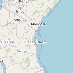
Over the past 30 days, Tanzania has recorded 5 earthquakes of magnitude 2.5 or greater in our tracker. 5 landed between M4.0 and M4.9. By depth: 5 shallow (<70 km). 2 of the epicenters were offshore. All 5 solutions have been reviewed by a USGS seismologist.
Each row in the table below includes a narrative summary of the event, ordered by time. Use the column headers to sort or filter by magnitude.
| Time ↓ | Mag ↕ | Location ↕ | Depth ↕ | Felt ↕ | MMI | Alert | Status | Details |
|---|---|---|---|---|---|---|---|---|
2026-10-16 2026-10-16 16:17:25 UTC | 4.6mb | 43 km N of Kilimatinde, Tanzania -5.462°, 35.013° | 10.0 km | - | - | - | ✓ Reviewed | USGS → |
A magnitude 4.6 earthquake was recorded 43 km N of Kilimatinde, Tanzania on October 16, 2026 at 16:17 UTC. The event was offshore. See the M4.6 event page for the full report, ShakeMap, and citizen-reported intensity data. | ||||||||
2026-10-14 2026-10-14 09:16:18 UTC | 4.6mb | 42 km NNE of Kilimatinde, Tanzania -5.477°, 35.043° | 10.0 km | - | - | - | ✓ Reviewed | USGS → |
Seismographs logged a magnitude 4.6 earthquake 42 km NNE of Kilimatinde, Tanzania with origin time 09:16 UTC on October 14, 2026. See the M4.6 event page for the full report, ShakeMap, and citizen-reported intensity data. | ||||||||
2026-10-11 2026-10-11 17:08:25 UTC | 4.5mb | 17 km E of Mtinko, Tanzania -4.562°, 35.012° | 10.0 km | - | - | - | ✓ Reviewed | USGS → |
On October 11, 2026, Tanzania registered a magnitude 4.5 earthquake 17 km E of Mtinko, Tanzania at 17:08 UTC. The event was offshore. See the M4.5 event page for the full report, ShakeMap, and citizen-reported intensity data. | ||||||||
2026-10-11 2026-10-11 16:48:02 UTC | 4.7mb | 18 km NNW of Igugunu, Tanzania -4.402°, 34.594° | 10.0 km | - | - | - | ✓ Reviewed | USGS → |
On October 11, 2026 at 16:48 UTC, a magnitude 4.7 earthquake struck 18 km NNW of Igugunu, Tanzania. It is the largest earthquake currently listed for Tanzania over the past 30 days. See the M4.7 event page for the full report, ShakeMap, and citizen-reported intensity data. | ||||||||
2026-10-11 2026-10-11 16:47:45 UTC | 4.5mb | 23 km SSW of Katesh, Tanzania -4.714°, 35.290° | 10.0 km | - | - | - | ✓ Reviewed | USGS → |
At 16:47 UTC on October 11, 2026, a magnitude 4.5 tremor occurred 23 km SSW of Katesh, Tanzania. See the M4.5 event page for the full report, ShakeMap, and citizen-reported intensity data. | ||||||||
18 km NNW of Igugunu, Tanzania
2026-10-11
40 km S of Mbumi, Tanzania
2026-01-20
Data from USGS Earthquake Hazards Program. Updated every 5 minutes.
Tanzania straddles the East African Rift system with significant seismic activity in the western rift branch and around Lake Tanganyika.
In 2026, Tanzania has recorded 11 earthquakes of magnitude 2.5 or greater so far. The largest earthquake in Tanzania in 2026 was a magnitude 5.3 event near Mbumi, Tanzania.
Over the past 30 days, there have been 5 recorded earthquakes in this region. The largest recent earthquake was a magnitude 4.7 event near 18 km NNW of Igugunu, Tanzania.
In the past 30 days, 5 earthquakes have been recorded in the Tanzania region.
The largest recent earthquake in the Tanzania area was a magnitude 4.7 event that occurred 18 km NNW of Igugunu, Tanzania.
Malawi occupies the southern end of the East African Rift system with significan...
Kenya lies along the East African Rift Valley with active faults and volcanic fe...
Rwanda lies in the western branch of the East African Rift and experiences earth...
Uganda lies along the western branch of the East African Rift, experiencing eart...