M3.5 Earthquake 6 km E of Assaria, Kansas — February 25, 2026
2026-02-25 20:14:52 UTC (2026-02-25) · approx. 1:14 PM UTC-7 local
Felt by 43 people across nearby locations. Maximum shaking intensity MMI 4.3 (moderate).
On February 25, 2026 at 20:14 UTC, a magnitude 3.5 shallow crustal earthquake struck 6 km E of Assaria, Kansas, at a depth of 7.0 km and coordinates 38.6895°, -97.5314°. The earthquake was reported felt by 43 peopleacross nearby locations, with a maximum shaking intensity of Modified Mercalli Intensity (MMI) 4.3 (moderate). This earthquake was detected by 32 seismic stations with excellent location accuracy and was assigned a USGS significance rating of 205, placing it among routine seismic activity.
Physical scale: An earthquake of magnitude 3.5 releases seismic energy equivalent to roughly 2.7 metric tons of TNT. Empirical fault-scaling laws (Wells & Coppersmith, 1994) estimate the subsurface rupture length at approximately 157 m — a useful intuition for the size of the slip patch on the fault.

ShakeMap — predicted shaking intensity
Modeled ground-motion intensity contoured on the Modified Mercalli scale (MMI). Computed by the USGS from the moment-tensor solution and regional ground-motion prediction equations.
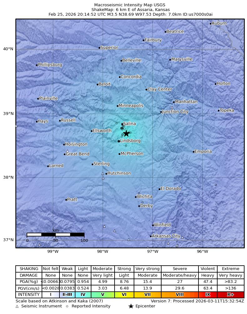
Source: U.S. Geological Survey ShakeMap. View interactive ShakeMap on USGS
Did You Feel It? — community-reported shaking
Aggregated felt-report intensity from 43 citizen responses to the USGS Did You Feel It? system. Each colored zone represents the average MMI from reports in that area.
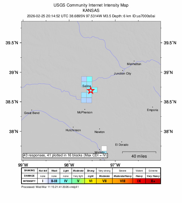
Source: U.S. Geological Survey Did You Feel It?. View on USGS · submit your own report
Earthquake Details
-97.5314°E
Technical Information
Common Questions
How strong was the magnitude 3.5 earthquake near Assaria, Kansas?
The magnitude 3.5 earthquake that struck 6 km E of Assaria, Kansas on February 25, 2026 at 20:14 UTC had a depth of 7.0 km. It was felt by 43 people with maximum shaking intensity of MMI 4.3 (moderate). For context, this was a minor earthquake typically detected only by instruments.
Where did the earthquake occur?
The earthquake epicenter was located at 38.6895°, -97.5314°, which is 6 km E of Assaria, Kansas.
Were there aftershocks?
Aftershock activity is monitored continuously by the USGS. Aftershock sequences from magnitude 3.5 earthquakes can continue for several days and gradually diminish over time.
What should I do after an earthquake?
If you were in the affected area: check yourself and others for injuries, inspect your home for damage, and be prepared for aftershocks. For detailed guidance, see our earthquake safety guide and emergency planning resources.
Authoritative source: USGS event page (event ID: us7000s0ai). All scientific values on this page are sourced verbatim from the USGS feed.
Cite this page: EarthquakeTracker.org. (2026, February 25, 2026). M3.5 Earthquake 6 km E of Assaria, Kansas — February 25, 2026. Retrieved May 12, 2026 from https://www.earthquaketracker.org/earthquakes/event/us7000s0ai/