Earthquakes in Washington

4 earthquakes in the last 24 hours• Latest significant: M3.8

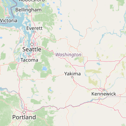
Earthquake Map

Map showing earthquake epicenter at 47.75°, -120.74°

Recent Earthquakes (Last 30 Days)

Dataset at a glance — Washington

Over the past 30 days, Washington has recorded 4 earthquakes of magnitude 2.5 or greater in our tracker. The remaining 4 fell in the M2.5–M3.9 band. By depth: 4 shallow (<70 km). 3 of the epicenters were offshore. 4 events produced at least one felt report, totalling 2,075 citizen submissions to the USGS Did You Feel It? system. Focal depths ranged from -0.3 km to 25.4 km. All 4 solutions have been reviewed by a USGS seismologist.

Each row in the table below includes a narrative summary of the event, ordered by time. Use the column headers to sort or filter by magnitude.

Showing 4 of 4
Time Mag Location Depth Felt MMIAlertStatusDetails
2026-07-09
2026-07-09 06:04:57 UTC
2.6ml
17 km SW of Nile, Washington
46.724°, -121.120°
8.7 km3--✓ ReviewedUSGS →
Seismographs logged a magnitude 2.6 earthquake 17 km SW of Nile, Washington with origin time 06:04 UTC on July 9, 2026. The event was offshore. See the M2.6 event page for the full report, ShakeMap, and citizen-reported intensity data.
2026-07-02
2026-07-02 06:35:47 UTC
3.8ml
2 km E of Oak Harbor, Washington
48.289°, -122.606°
25.4 km2,028III-✓ ReviewedUSGS →
On July 2, 2026 at 06:35 UTC, a magnitude 3.8 earthquake struck 2 km E of Oak Harbor, Washington. It is the largest earthquake currently listed for Washington over the past 30 days. See the M3.8 event page for the full report, ShakeMap, and citizen-reported intensity data.
2026-06-26
2026-06-26 08:06:54 UTC
2.5ml
11 km E of Carnation, Washington
47.630°, -121.759°
17.1 km12--✓ ReviewedUSGS →
On June 26, 2026, Washington registered a magnitude 2.5 earthquake 11 km E of Carnation, Washington at 08:06 UTC. The event was offshore. See the M2.5 event page for the full report, ShakeMap, and citizen-reported intensity data.
2026-06-26
2026-06-26 05:31:29 UTC
2.8ml
1 km SSE of Easton, Washington
47.224°, -121.169°
-0.3 km32--✓ ReviewedUSGS →
A magnitude 2.8 earthquake was recorded 1 km SSE of Easton, Washington on June 26, 2026 at 05:31 UTC. This is the shallowest earthquake in the current dataset — a shallow crustal event. See the M2.8 event page for the full report, ShakeMap, and citizen-reported intensity data.
Legend:
Mag: Magnitude (magType = ml, mb, mw, etc.)
Felt: Number of DYFI felt reports
MMI: Modified Mercalli Intensity (I-X+)
Alert: PAGER alert level
Depth: Shallow (<70km), Intermediate, Deep (>300km)
Status: Auto = preliminary, Reviewed = verified by seismologist
Click any row to see additional technical details.

Earthquake Statistics

Last 24 Hours4
Last 30 Days4
2026 (M2.5+)18

Largest (30 Days)
M3.8

2 km E of Oak Harbor, Washington

2026-07-02

Largest in 2026
M3.8

2 km E of Oak Harbor, Washington

2026-07-02

Seismic Risk Level
High

Data from USGS Earthquake Hazards Program. Updated every 5 minutes.

About Washington

Washington State faces significant earthquake risk from the Cascadia Subduction Zone, capable of producing magnitude 9+ earthquakes. The Seattle area also has local fault systems that pose additional risk.

Washington Earthquakes 2026

In 2026, Washington has recorded 18 earthquakes of magnitude 2.5 or greater so far. The largest earthquake in Washington in 2026 was a magnitude 3.8 event near Oak Harbor, Washington.

Seismic Activity in Washington

Washington has a High seismic risk level based on historical earthquake data and proximity to active fault lines.

Over the past 30 days, there have been 4 recorded earthquakes in this region. The largest recent earthquake was a magnitude 3.8 event near 2 km E of Oak Harbor, Washington.

Frequently Asked Questions

How many earthquakes occur in Washington?

In the past 30 days, 4 earthquakes have been recorded in the Washington region.

What was the biggest recent earthquake in Washington?

The largest recent earthquake in the Washington area was a magnitude 3.8 event that occurred 2 km E of Oak Harbor, Washington.