M5.2 Earthquake 122 km NW of Maubara, Timor Leste — April 20, 2026
2026-04-20 05:19:35 UTC (2 days ago)
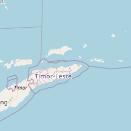
On April 20, 2026 at 05:19 UTC, a magnitude 5.2 intermediate depth earthquake struck 122 km NW of Maubara, Timor Leste, at a depth of 183.1 km and coordinates -7.9677°, 124.3047°. This earthquake was detected by 32 seismic stations with good location accuracy and was assigned a USGS significance rating of 416, placing it among routine seismic activity.
Earthquake Details
124.3047°E
Technical Information
Nearby Earthquakes (Last 7 Days)
Common Questions
How strong was the magnitude 5.2 earthquake near Maubara, Timor Leste?
The magnitude 5.2 earthquake that struck 122 km NW of Maubara, Timor Leste on April 20, 2026 at 05:19 UTC had a depth of 183.1 km. For context, this was a moderate earthquake that could be widely felt.
Where did the earthquake occur?
The earthquake epicenter was located at -7.9677°, 124.3047°, which is 122 km NW of Maubara, Timor Leste.
Were there aftershocks?
Aftershock activity is monitored continuously by the USGS. Aftershock sequences from magnitude 5.2 earthquakes can continue for days to weeks and gradually diminish over time.
What should I do after an earthquake?
If you were in the affected area: check yourself and others for injuries, inspect your home for damage, and be prepared for aftershocks. For detailed guidance, see our earthquake safety guide and emergency planning resources.