M4.1 Earthquake 20 km SE of Silver Springs, Nevada — May 1, 2026
2026-05-01 08:15:55 UTC (2 hours ago) · approx. 12:15 AM UTC-8 local
Felt by 31 people across nearby locations. Maximum shaking intensity MMI 4.6 (moderate). Aftershock of the M5.7 mainshock.
On May 1, 2026 at 08:15 UTC, a magnitude 4.1 shallow crustal earthquake struck 20 km SE of Silver Springs, Nevada, at a depth of 10.8 km and coordinates 39.3035°, -119.0377°. The earthquake was reported felt by 31 peopleacross nearby locations, with a maximum shaking intensity of Modified Mercalli Intensity (MMI) 4.6 (moderate). The USGS PAGER system issued a green alert level for this event, indicating no significant casualties or damage expected. This earthquake was detected by 37 seismic stations with good location accuracy and was assigned a USGS significance rating of 275, placing it among routine seismic activity. The nearest populated place is Silver Springs (population 4,684).
Physical scale: An earthquake of magnitude 4.1 releases seismic energy equivalent to roughly 24 metric tons of TNT. Empirical fault-scaling laws (Wells & Coppersmith, 1994) estimate the subsurface rupture length at approximately 426 m — a useful intuition for the size of the slip patch on the fault.
This earthquake is part of an ongoing aftershock sequence following the magnitude 5.7 mainshock that occurred 17 days ago 20 km ESE of Silver Springs, Nevada. Since the mainshock, the USGS has recorded 200 aftershocks in this area. Aftershock activity is expected to continue for days to weeks as stresses on surrounding faults redistribute.
The epicenter is located in Nevada, a region characterized by Basin and Range extensional tectonics, where normal faulting accommodates east-west crustal stretching at approximately 10 mm per year. The nearest mapped fault system is the Walker Lane fault zone. View all earthquakes in Nevada.
Learn more: Magnitude scale · Aftershock sequences
Nearest Populated Places

ShakeMap — predicted shaking intensity
Modeled ground-motion intensity contoured on the Modified Mercalli scale (MMI). Computed by the USGS from the moment-tensor solution and regional ground-motion prediction equations.
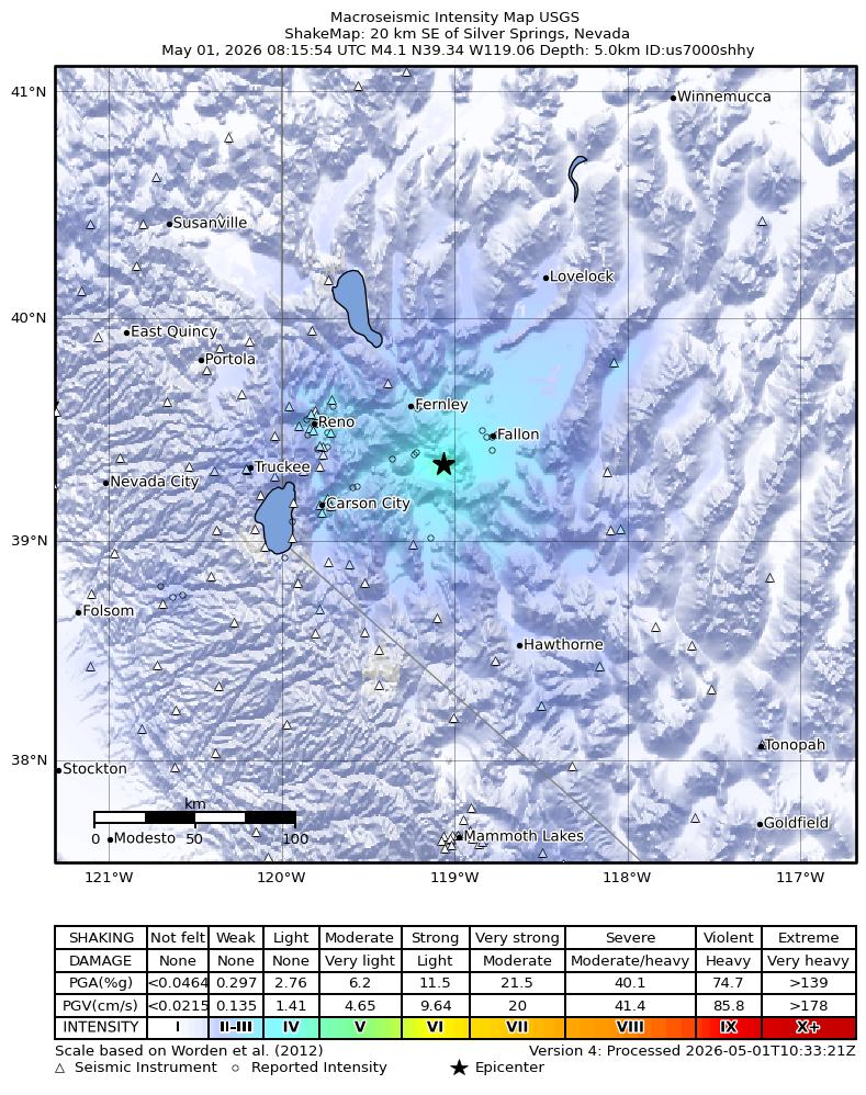
Source: U.S. Geological Survey ShakeMap. View interactive ShakeMap on USGS
Did You Feel It? — community-reported shaking
Aggregated felt-report intensity from 31 citizen responses to the USGS Did You Feel It? system. Each colored zone represents the average MMI from reports in that area.
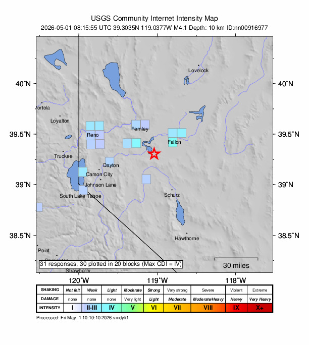
Source: U.S. Geological Survey Did You Feel It?. View on USGS · submit your own report
Population exposure (USGS PAGER)
Estimated population that experienced each level of shaking. Based on the USGS PAGER rapid impact assessment, which combines ShakeMap output with global population grids.
| Shaking intensity (MMI) | Description | Population exposed |
|---|---|---|
| MMI 3 | weak | 564,103 |
| MMI 4 | light | 5,679 |
Earthquake Details
-119.0377°E
Technical Information
Nearby Earthquakes (Last 7 Days)
Common Questions
How strong was the magnitude 4.1 earthquake near Silver Springs, Nevada?
The magnitude 4.1 earthquake that struck 20 km SE of Silver Springs, Nevada on May 1, 2026 at 08:15 UTC had a depth of 10.8 km. It was felt by 31 people with maximum shaking intensity of MMI 4.6 (moderate). For context, this was a light earthquake commonly felt near the epicenter.
Where did the earthquake occur?
The earthquake epicenter was located at 39.3035°, -119.0377°, which is 20 km SE of Silver Springs, Nevada. The nearest populated place is Silver Springs (population 4,684). View all earthquakes in Nevada.
Were there aftershocks?
Aftershock activity is monitored continuously by the USGS. Aftershock sequences from magnitude 4.1 earthquakes can continue for several days and gradually diminish over time.
Is this the same earthquake as the M5.7 one earlier?
No. This magnitude 4.1 earthquake is an aftershock of the larger magnitude 5.7 mainshock that occurred earlier 20 km ESE of Silver Springs, Nevada. Aftershocks are smaller earthquakes triggered by stress changes from the mainshock.
Has Nevada had earthquakes this big before?
The largest recorded earthquake in Nevada was the M7.3 Pleasant Valley earthquake of October 2, 1915. Today's magnitude 4.1 event is significantly smaller than that historical record.
What should I do after an earthquake?
If you were in the affected area: check yourself and others for injuries, inspect your home for damage, and be prepared for aftershocks. For detailed guidance, see our earthquake safety guide and emergency planning resources.
Authoritative source: USGS event page (event ID: nn00916977). All scientific values on this page are sourced verbatim from the USGS feed.
Cite this page: EarthquakeTracker.org. (2026, May 1, 2026). M4.1 Earthquake 20 km SE of Silver Springs, Nevada — May 1, 2026. Retrieved May 1, 2026 from https://www.earthquaketracker.org/earthquakes/event/nn00916977/