M3.6 Earthquake 7 km ESE of Cloverdale, CA — June 2, 2026
2026-06-02 16:44:19 UTC (2026-06-02) · approx. 8:44 AM UTC-8 local
Felt by 80 people across nearby locations.
On June 2, 2026 at 16:44 UTC, a magnitude 3.6 shallow crustal earthquake struck 7 km ESE of Cloverdale, CA, at a depth of 5.5 km and coordinates 38.7863°, -122.9370°. The earthquake was reported felt by 80 peopleacross nearby locations, with a maximum shaking intensity of Modified Mercalli Intensity (MMI) 3.8 (light). This earthquake was detected by 116 seismic stations with excellent location accuracy and was assigned a USGS significance rating of 231, placing it among routine seismic activity.
Physical scale: An earthquake of magnitude 3.6 releases seismic energy equivalent to roughly 4.2 metric tons of TNT. Empirical fault-scaling laws (Wells & Coppersmith, 1994) estimate the subsurface rupture length at approximately 193 m — a useful intuition for the size of the slip patch on the fault.
The epicenter is located in California, a region characterized by the San Andreas transform fault system, where the Pacific and North American plates slide past each other at roughly 46 mm per year. The nearest mapped fault system is the San Andreas Fault. View all earthquakes in California.
Learn more: San Andreas Fault · Magnitude scale · Aftershock sequences

ShakeMap — predicted shaking intensity
Modeled ground-motion intensity contoured on the Modified Mercalli scale (MMI). Computed by the USGS from the moment-tensor solution and regional ground-motion prediction equations.
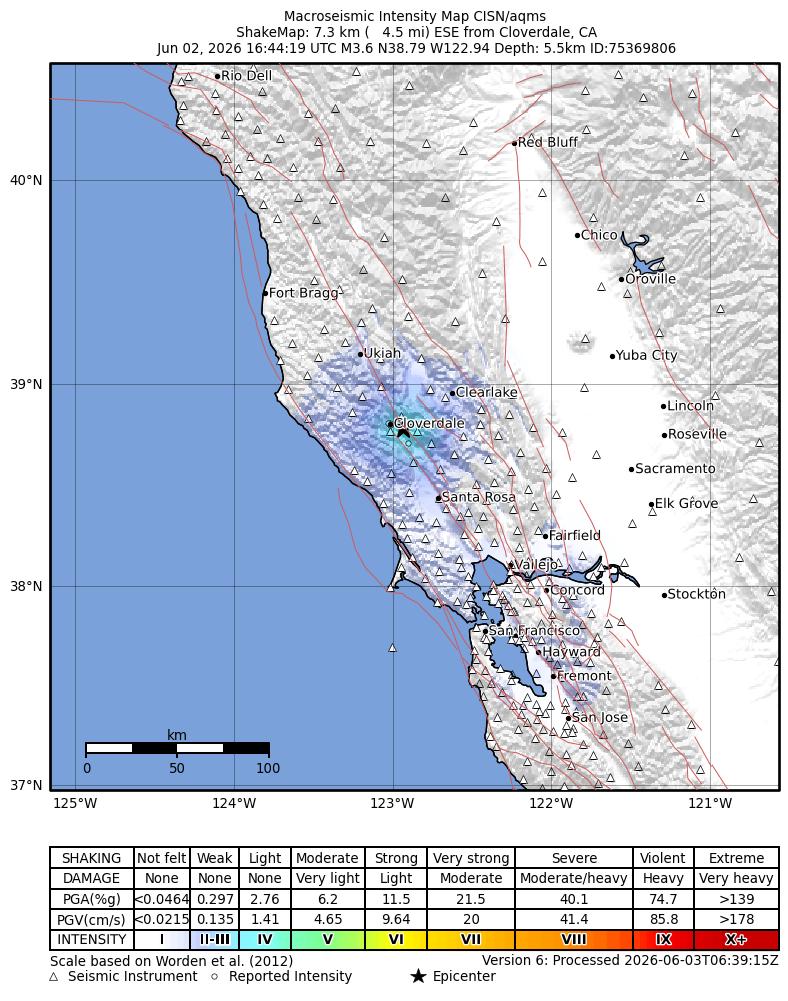
Source: U.S. Geological Survey ShakeMap. View interactive ShakeMap on USGS
Did You Feel It? — community-reported shaking
Aggregated felt-report intensity from 80 citizen responses to the USGS Did You Feel It? system. Each colored zone represents the average MMI from reports in that area.
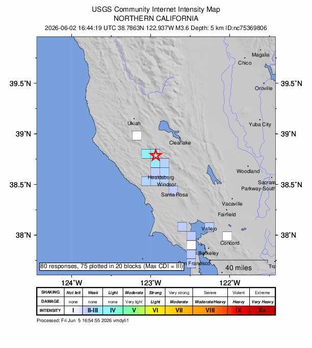
Source: U.S. Geological Survey Did You Feel It?. View on USGS · submit your own report
Earthquake Details
-122.9370°E
Technical Information
Nearby Earthquakes (Last 7 Days)
Common Questions
How strong was the magnitude 3.6 earthquake near Cloverdale, CA?
The magnitude 3.6 earthquake that struck 7 km ESE of Cloverdale, CA on June 2, 2026 at 16:44 UTC had a depth of 5.5 km. It was felt by 80 people with maximum shaking intensity of MMI 3.8 (light). For context, this was a minor earthquake typically detected only by instruments.
Where did the earthquake occur?
The earthquake epicenter was located at 38.7863°, -122.9370°, which is 7 km ESE of Cloverdale, CA. View all earthquakes in California.
Were there aftershocks?
Aftershock activity is monitored continuously by the USGS. Aftershock sequences from magnitude 3.6 earthquakes can continue for several days and gradually diminish over time.
Has California had earthquakes this big before?
The largest recorded earthquake in California was the M7.9 Fort Tejon earthquake of January 9, 1857. Today's magnitude 3.6 event is significantly smaller than that historical record.
Actions
Authoritative source: USGS event page (event ID: nc75369806). All scientific values on this page are sourced verbatim from the USGS feed.
Cite this page: EarthquakeTracker.org. (2026, June 2, 2026). M3.6 Earthquake 7 km ESE of Cloverdale, CA — June 2, 2026. Retrieved June 24, 2026 from https://www.earthquaketracker.org/earthquakes/event/nc75369806/