2.0
M2.0 Earthquake 41 km W of Tatitlek, Alaska — May 16, 2026
2026-05-16 14:19:01 UTC (3 days ago) · approx. 4:19 AM UTC-10 local
MagnitudeM2.0(ml)
Time14:19 UTC≈ 4:19 AM UTC-10
Depth4.1 kmshallow crustal
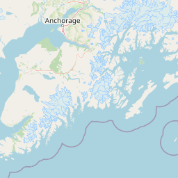
Coordinates60.865°, -147.448°
Felt byNo felt reports
Status✓ Reviewed by USGS
Earthquake Details
Magnitude
2.0 ml
Depth
4.1 km
shallow crustal
Location
60.8650°N
-147.4480°E
-147.4480°E
Technical Information
Event ID
aka2026jqlpny
Event Type
earthquake
Status
✓ Reviewed
Significance
62
Stations Used
44
Azimuthal Gap
58.0°
Min Station Distance
0.200°
RMS Residual
1.00 sec
Last Updated
2026-05-18 20:13:14 UTC
Nearby Earthquakes (Last 7 Days)
2.72.52.63.23.83.23.02.62.82.5
164 km N of Yakutat, Alaska
2 hours ago · 16.6 km deep
3 km S of Salcha, Alaska
5 hours ago · 6.8 km deep
11 km W of Four Mile Road, Alaska
8 hours ago · 18.3 km deep
57 km N of Petersville, Alaska
10 hours ago · 116.5 km deep
63 km W of Skwentna, Alaska
18 hours ago · 158.5 km deep
250 km ESE of Chiniak, Alaska
1 day ago · 18.3 km deep
7 km NE of Chase, Alaska
2 days ago · 65.1 km deep
37 km WSW of Womens Bay, Alaska
2 days ago · 57.6 km deep
46 km S of Nelchina, Alaska
2 days ago · 22.5 km deep
104 km N of Yakutat, Alaska
2 days ago · 1.9 km deep
Actions
Understanding This Data
Magnitude 2.0 earthquakes are typically only recorded by instruments.
Authoritative source: USGS event page (event ID: aka2026jqlpny). All scientific values on this page are sourced verbatim from the USGS feed.
Cite this page: EarthquakeTracker.org. (2026, May 16, 2026). M2.0 Earthquake 41 km W of Tatitlek, Alaska — May 16, 2026. Retrieved May 19, 2026 from https://www.earthquaketracker.org/earthquakes/event/aka2026jqlpny/