2.1
M2.1 Earthquake 22 km WNW of Bear Creek, Alaska — January 27, 2022
2022-01-27 21:45:13 UTC (2022-01-27) · approx. 11:45 AM UTC-10 local
MagnitudeM2.1(ml)
Time21:45 UTC≈ 11:45 AM UTC-10
Depth31.3 kmshallow crustal
Coordinates60.242°, -149.768°
Felt byNo felt reports
Status✓ Reviewed by USGS
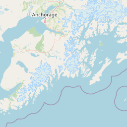
Earthquake Details
Magnitude
2.1 ml
Depth
31.3 km
shallow crustal
Location
60.2415°N
-149.7679°E
-149.7679°E
Technical Information
Event ID
ak022190a59s
Event Type
earthquake
Status
✓ Reviewed
Significance
68
RMS Residual
0.54 sec
Last Updated
2022-02-19 19:31:08 UTC
Nearby Earthquakes (Last 7 Days)
2.52.72.52.83.52.93.92.92.72.5
56 km WNW of Anchor Point, Alaska
6 hours ago · 100.4 km deep
38 km E of Pedro Bay, Alaska
1 day ago · 134.9 km deep
18 km N of Moose Pass, Alaska
1 day ago · 7.1 km deep
51 km WNW of Nikiski, Alaska
2 days ago · 103.6 km deep
21 km NE of Valdez, Alaska
3 days ago · 12.7 km deep
44 km W of Happy Valley, Alaska
3 days ago · 102.9 km deep
62 km S of Cantwell, Alaska
3 days ago · 70.3 km deep
46 km E of Pedro Bay, Alaska
3 days ago · 129.5 km deep
21 km SSW of Sunrise, Alaska
3 days ago · 24.7 km deep
104 km SSE of Old Harbor, Alaska
4 days ago · 20.1 km deep
Actions
Understanding This Data
Magnitude 2.1 earthquakes are typically only recorded by instruments.
Authoritative source: USGS event page (event ID: ak022190a59s). All scientific values on this page are sourced verbatim from the USGS feed.
Cite this page: EarthquakeTracker.org. (2022, January 27, 2022). M2.1 Earthquake 22 km WNW of Bear Creek, Alaska — January 27, 2022. Retrieved February 19, 2022 from https://www.earthquaketracker.org/earthquakes/event/ak022190a59s/